


Introduction
Pedestrian surveys of the coastal valleys of northern Peru have painstakingly recorded archaeological traces of complex social relations through time (Willey Reference Willey1953; Daggett Reference Daggett, Hass, Pozorski and Pozorski1987; Wilson Reference Wilson1988; Dillehay et al. Reference Dillehay, Kolata and Swenson2009). Each of these investigations has documented cultural development through a repeated pattern of desert coastal plains, fertile irrigated valleys and the imposing foothills of the Andes, creating invaluable records of site distributions (Figure 1). While the Pacific Ocean defines the western edge of these survey areas, their upland boundaries have typically been delineated by the steep Andean foothills, which archaeologists have tended to treat as a natural—and by extension, cultural—barrier between coastal and highland groups. Yet far from being a hard boundary, these foothills were also areas of intense—and often violent—interaction, as evidenced by the presence of hilltop fortifications dating to the Middle Horizon (AD 500–1000) and Late Intermediate Period (AD 1000–1450).
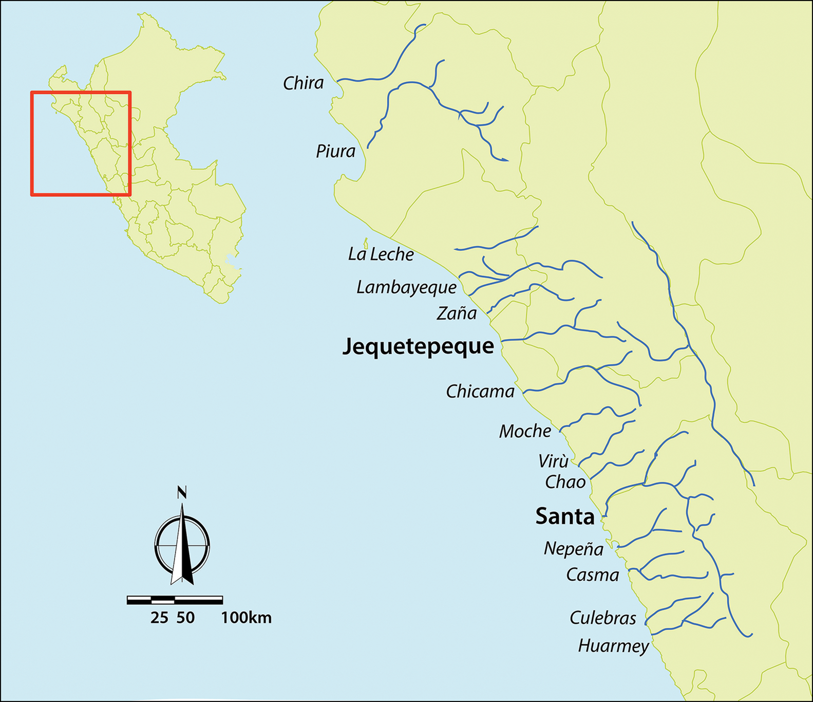
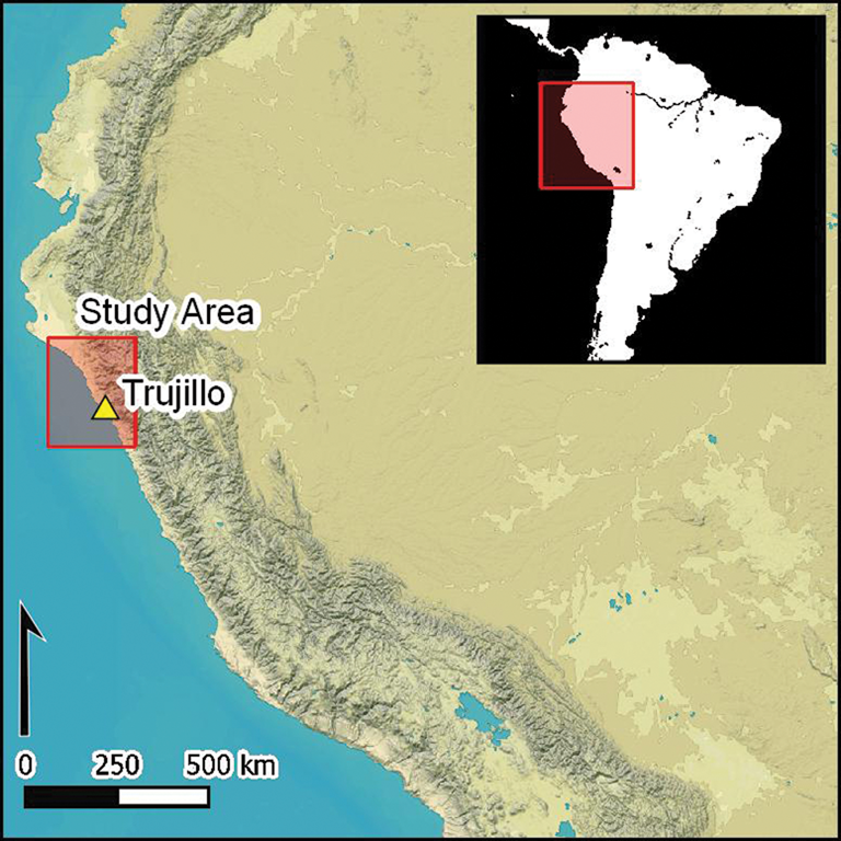
Figure 1. Map of river valleys along the north coast of Peru (figure by the authors).
The preponderance of defensive sites may reflect increased highland cultural influence and incursion or potential internal conflict towards the end of the Moche period (AD 650–950) (Dillehay Reference Dillehay and Pillsbury2001). But the prevalence and distribution of these hilltop fortifications, variously referred to as pukaras or refugia, is poorly understood precisely because they are located near the edge of most pedestrian surveys. Given the challenging topography of the coastal mountains, most early surveys relied upon limited aerial and satellite imagery rather than pedestrian reconnaissance for some of the more inaccessible areas. Our understanding of Moche period defensive networks is relatively poor as a result. Fortunately, defensive infrastructures in these remote locations are visually diagnostic, making them excellent candidates for digital survey using modern high-resolution imagery. In their overview of the Antiquity GeoPACHA articles (see Wernke et al. Reference Wernke2023), Wernke, VanValkenburgh and colleagues discuss these kinds of sample size and sample bias problems in archaeology more broadly, and how the Geospatial Platform for Andean Culture, History and Archaeology (GeoPACHA) addresses these challenges by enabling inter-regional scale distributional views of archaeological phenomena. By comparing the results of high-resolution satellite survey to those of traditional pedestrian techniques, this article will serve as a test of the degree to which the GeoPACHA can build upon, ameliorate and potentially expand previous research efforts in the coastal mountains of northern Peru. For this study, pedestrian surveys in the Jequetepeque Valley (Dillehay & Kolata Reference Dillehay and Kolata1997) and Lower Santa Valley (Wilson Reference Wilson1988) are chosen as areas of comparison to satellite survey due to their detailed coverage at all elevations and the use of stable data schema in their research designs.
Moche Period fortifications in the Jequetepeque and Santa Valleys
The late Moche period was a time of social instability; as the more centralised and hierarchical polities that characterised the preceding era began to break down, structured violent conflict appears to have become a common feature of Late Moche social life (Dillehay Reference Dillehay and Pillsbury2001). In contrast to earlier periods marked by greater centralisation of proto-urban settlements, Late Moche communities apparently adhered to their local homelands regardless of periodic environmental perturbations brought about by El Niño Southern Oscillation events and other risks. In response to this instability, communities reified regional social cohesion through notable increases in the construction of defensive infrastructure.
Some of these fortified sites were temporary defensive localities for populations living at larger sites, or individual refuge sites for rural hinterland centres (Dillehay Reference Dillehay and Pillsbury2001; Swenson Reference Swenson2004; Wai Reference Wai2019). Hilltop forts in the foothills of the Santa and Moche Valleys vary in their degree of design complexity, incorporating settlement and ceremonial zones (Topic & Topic Reference Topic, Topic, Hass, Pozorski and Pozorski1987; Dillehay Reference Dillehay and Pillsbury2001; Swenson Reference Swenson2004). Many would suffice only as temporary refuges from conflict, while others are considerably more complex arrangements with domestic and ritual architecture.
Intermediate sized enclaves were generally within 2–5km of larger settlements, with smaller areas of occupation further afield along local stream courses. Dillehay notes that some of the enclaves were widely distributed, with unfarmed land interspaced, whereas others lay in close proximity to each other, such that “occasional disputes over land and water almost certainly occurred” (Dillehay Reference Dillehay and Pillsbury2001: 270). The location of Moche settlements along rivers provided access to water for small-scale irrigation systems, while the topography of the hillslopes provided relatively defensible contexts, enabling views of approaching threats and the tactical advantage of defence from on high (Topic & Topic Reference Topic and Topic1978, Reference Topic, Topic, Hass, Pozorski and Pozorski1987).
In the Jequetepeque and Zaña Valleys, the mountaintop fortresses of Cerro Faclo and Cerro La Guitarra reflect military threats, along with most hilltop fortresses associated with small and intermediate communities (VanValkenburgh Reference VanValkenburgh2012). Combat and raiding appear to have been common both within Moche society and in interactions with neighbouring peoples, as implied by the location of hilltop fortresses immediately above settlements. Dillehay suggests that the larger number of fortresses in the Jequetepeque and Zaña Valleys might be related to the location of these valleys at a frontier between conflicting polities in the Lambayeque Valley to the north (Dillehay Reference Dillehay and Pillsbury2001; Dillehay et al. Reference Dillehay, Kolata and Swenson2009). The number of hilltop fortifications associated with ceramics from the Late Moche period suggests that periodic conflict and more organised warfare were frequent towards the end of the Moche era.
Evidence of community defence is clear in the presence and form of massive stone defensive walls and rock cut ditches at the Jequetepeque Valley sites of Cerro Chepen, Cerro Faclo and Cerro Prieto Espinal (Swenson Reference Swenson2004; Dillehay et al. Reference Dillehay, Kolata and Swenson2009; Wai Reference Wai2019). But it is far more difficult to identify weapons used in attack and, in truth, there is minimal evidence of these sites ever having been raided. Within the hilltop fortresses, there are large storage vessels for water and food and piles of slingstones on defensive walls, however the preponderance of loose rock at these sites would have also easily provided expedient ammunition outside of carefully selected projectiles (Topic & Topic Reference Topic, Topic, Hass, Pozorski and Pozorski1987). Many other sites not associated with adjacent hilltop forts contain enclosure walls that clearly would have provided a degree of protection, or at least controlled access into the communities. There is little archaeological evidence that suggests that any of the sites were destroyed during attacks.
Given the archaeological evidence for conflict preparedness, Dillehay (Reference Dillehay and Pillsbury2001) suggests that the size differences between some large hilltop forts and the numerous settlements within a particular catchment might indicate that these were a form of communal defensive infrastructure that would have been built by a confederation of communities, but not of a central state. He suggests that the construction may have been ongoing works of communal defence (akin to pitching in to build an air-raid shelter) that suggests a heterarchical system that was more fluid than a monolithic central authority.
Dillehay also suggests that the eventual Moche collapse may be the outcome of competition over the most productive land, with warfare as a means of boundary maintenance and for supplementing local supplies with loot and captives for sacrifice and enslavement (Dillehay Reference Dillehay and Pillsbury2001). Following Moche iconography, it has long been suggested that conflict among neighbouring populations may have been the ritual domain of competing elites within a centralised polity (Topic & Topic Reference Topic, Topic, Hass, Pozorski and Pozorski1987). The location of these battles remains conjectural, with no data to suggest that they occurred within centralised urban or non-centralised rural political contexts and settings. There are indications from the iconography that the settings for battles were often in mountainside locations, artistic efforts that repeatedly show that these conflicts occurred outside of communities, in the open and uninhabited plains between settlements (Donnan & McClelland Reference Donnan and McClelland1999).
Dillehay (Reference Dillehay and Pillsbury2001) and Swenson (Reference Swenson2004) both postulate that Late Moche communities may have been highly mobile and dispersed into smaller rural settlements that gathered at the larger ceremonial sites as part of a ritual round. From this perspective, this more defensive and economically minded movement from locality to locality was evidence of a “foraging” urban modality, leaving behind a “thin and redundant archaeological pattern” (Dillehay Reference Dillehay and Pillsbury2001: 277). Occupation of sites may have been fleeting, tenuous attempts to extract resources while actively preparing for attack. Such an unstable, fractured social structure may suggest that the presence of rural hamlets and associated defensible locations was a harbinger of the very end of the Late Moche period, a time of retreat from abandoned larger centres to small cellular communities eking out meagre subsistence economies while keeping an eye on the horizon for competing communities. It remains unclear whether such shifts in occupation were common throughout the region since the relevant mountainous areas are near the limits of field surveys.
Previous surveys in the Jequetepeque Valley
The Jequetepeque Valley has been the subject of multiple archaeological surveys, which have ranged from targeted investigations of specific regions of the valley (Ravines Reference Ravines1981) to valley-wide surveys (Eling Reference Eling, Matos, Turpin and Eling1986, Reference Eling1987; Hecker & Hecker Reference Hecker and Hecker1990; Dillehay et al. Reference Dillehay, Warner, Iriarte and Kolata1998, Reference Dillehay, Kolata, Swenson, Stvan and Warner1999, Reference Dillehay, Kolata and Swenson2000, Reference Dillehay, Kolata and Swenson2001, Reference Dillehay, Kolata and Swenson2009). The Hecker and Hecker survey (1990) relied heavily upon aerial photographs and focused on the identification of habitation sites based on the presence of standing architecture. Ephemeral sites were therefore not located during the course of this work, and agricultural infrastructure and ceramic scatters were not noted. As a result, the Jequetepeque Valley hinterland was considered to be relatively devoid of habitation.
The Proyecto Jequetepeque (1997–2001) achieved more systematic coverage through a valley-wide pedestrian survey designed to study long-term human–environment interactions. The project's survey campaign covered approximately 3200km2, wherein all sites (pre-ceramic through to historical) and archaeological features from San José de Moro in the north to the Quebrada Cupisnique in the south were recorded (Figure 2). Conducting survey on foot, this project attempted to record all sites and features irrespective of size and complexity. Larger settlements and agricultural infrastructure were mapped in detail, while many ephemeral features, including pre-ceramic lithic scatters, ceramic concentrations and minor settlement clusters were documented for the first time (Dillehay & Kolata Reference Dillehay and Kolata1997; Dillehay & Kolata Reference Dillehay and Kolata2004; Dillehay et al. Reference Dillehay, Warner, Iriarte and Kolata1998, Reference Dillehay, Kolata, Swenson, Stvan and Warner1999, Reference Dillehay, Kolata and Swenson2000, Reference Dillehay, Kolata and Swenson2001, Reference Dillehay, Kolata and Swenson2009; Swenson Reference Swenson2004; Stackelbeck Reference Stackelbeck2008; Maggard Reference Maggard2010; Warner Reference Warner2010). While the use of a hand-held Global Positioning System (GPS) receiver resulted in somewhat lower spatial precision in comparison to those afforded by contemporary global navigation satellite systems mapping techniques, the general location of sites is sufficient to allow for comparison to the findings of the current study using GeoPACHA.
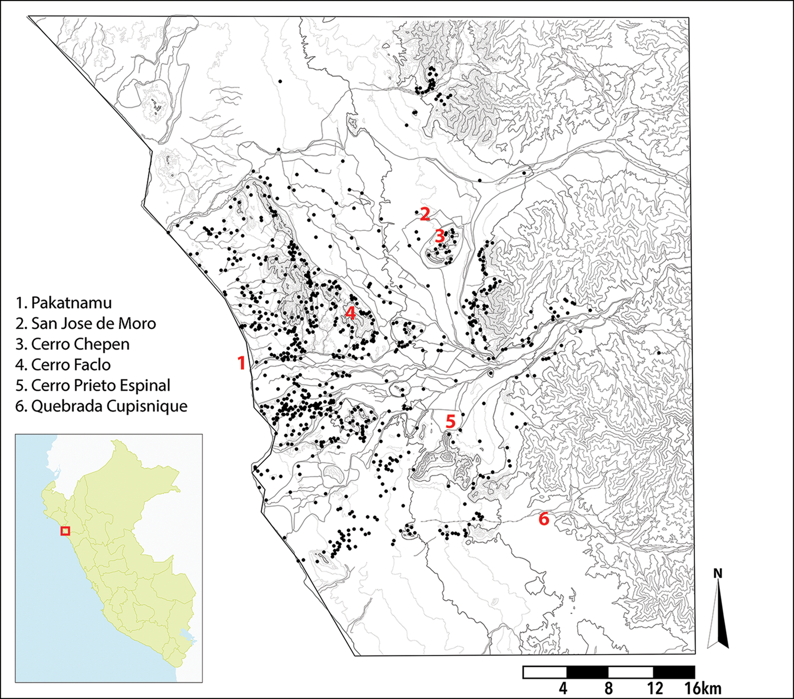
Figure 2. Map of all site locations found during the Proyecto Jequetepeque pedestrian survey (modified from Dillehay et al. Reference Dillehay, Kolata and Swenson2009; figure by the authors).
In total, the Proyecto Jequetepeque registered 1027 sites, with 322 of these assigned to the Late Moche period (AD 600–750). Of this total, only 50 sites were recorded as having defensive qualities. These will be the focus of the comparisons discussed below. The pedestrian survey took place over a cumulative total of 210 days of fieldwork (1680 hours collectively), by two or three teams of four surveyors (approximately 13 440–20 160 individual hours of physical labour, not including site documentation in lab settings). Sites were recorded on paper copies of aerial photographs obtained from the Servicio Aerofotográfico Nacional and Google Earth, as well as GPS points taken with Magellan and Garmin devices. Many of the larger, more complex sites were additionally mapped with a Trimble GPS as well as Total Station mapping, where feasible.
Among the sites registered, large or intermediate-sized walled towns, with complexes of tightly compacted stone and adobe brick architecture, appear to have increased in number during the Late Moche period. Most of these settlements follow the local hillside topography. The survey also documented massive mountaintop forts, fortified hilltop communities and agricultural fields associated with strategic points in the valley. Outside of Wilson's survey of the Lower Santa Valley, discussed in the following section, these types of sites had not previously been documented for the Moche period. The hillfort communities range in size between 25 and 40ha, while the mountain top forts range between 12 and 20ha (Dillehay et al. Reference Dillehay, Kolata and Swenson2009).
It bears emphasis that there is some difficulty in defining defensive architecture in the absence of defensive walls. Many sites with controlled access, such as the ceremonial centre of Pacatnamu near the mouth of the Jequetepeque Valley, were functionally defensive but not located at the peak of coastal hills or mountains. From this perspective, the definition of ‘refugia’ versus ‘fortress’ versus ‘fortified settlements’ specific to each survey requires consideration. For the purposes of comparison across both pedestrian and digital surveys, any sites that contain structural elements noted as having defensive qualities were included in totals, from elaborate defensive walls surrounding true forts to modest slingstone piles along a ridgeline. The Proyecto Jequetepeque survey did not carry out extensive survey in the central coastal plain of the valley, but cursory inspection of the area indicated that most sites were small to intermediate in size and did not include the remains of monumental adobe structures (huacas).
Previous surveys in the lower Santa Valley
Prior to Wilson's expansive 1979–80 survey, numerous archaeological investigations involving site reconnaissance had been conducted across the Santa Valley. Excavations conducted by G.A. Dorsey in 1892, Rafael Larco Hoyle in 1934 (Larco Hoyle Reference Larco Hoyle1963), William Clothier in 1943 (Clothier Reference Clothier1943) and Christopher Donnan in 1966–67 (Donnan Reference Donnan1973) focused on targeted mapping and excavation of cemetery sites. Aerial photographs taken by the Shippee-Johnson Peruvian Expedition in 1931 first documented over 40 hilltop fortresses in the region (Shippee Reference Shippee1932, Reference Shippee1933), and a brief survey by James Ford in 1946 (Ford Reference Ford1949) documented 58 other occupation sites in the middle and lower parts of the Santa Valley. Paul Kosok's 1949 survey of irrigation networks documented 40 additional sites (Kosok Reference Kosok1965), which was followed by work in the 1950s and 1960s by Hans Horkheimer (Reference Horkheimer1965), Gary Vescelius and, most notably, by Mercedes Cárdenas (Cárdenas Martín Reference Cárdenas Martín1977) who mapped 187 sites across the region (Wilson Reference Wilson1988:8).
Expanding upon this previous work, Wilson's survey covered an area of approximately 750km2 of the coastal and inland sectors of the lower Santa Valley, including the Quebrada de Lacramarca and the interface of the Santa-Chao desert at the north of the research area (Figure 3). In total, this survey registered 1020 discrete archaeological sites, with 226 additional sites defined within multicomponent phases of occupation (Wilson Reference Wilson1983, Reference Wilson1985, Reference Wilson, Hass, Pozorski and Pozorski1987, Reference Wilson1988). This survey took place over a period of nine months of fieldwork, mapping and surface collection, followed by three months of laboratory analysis. In total, the lower Santa Valley survey was conducted over 150 days by a single team of three to five people (approximately 1200 hours collectively, or 3600–6000 individual hours).
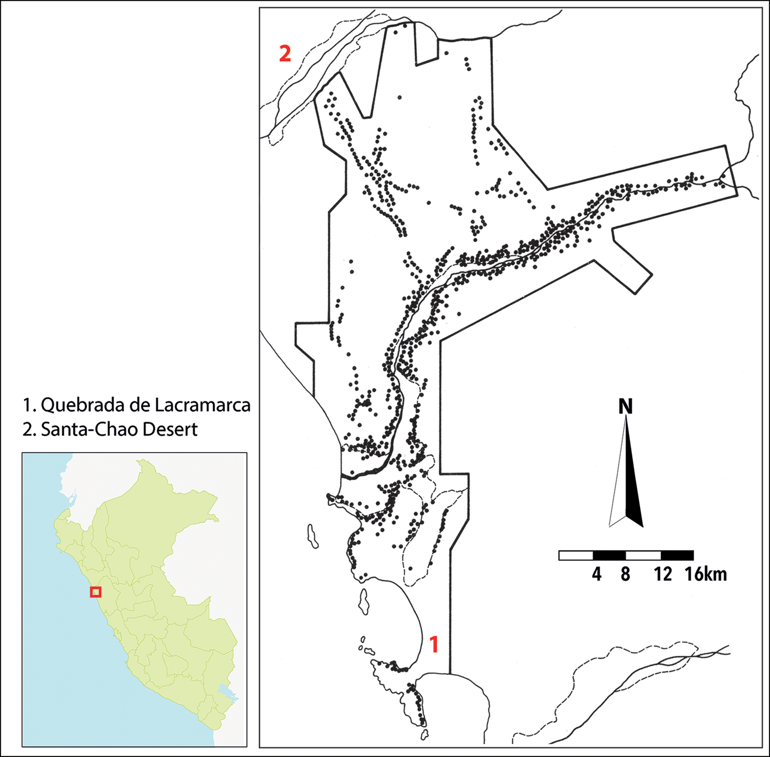
Figure 3. Map of all site locations found during the lower Santa Valley pedestrian survey (modified from Wilson Reference Wilson1988; figure by the authors).
While employing similar methods to the subsequent Proyecto Jequetepeque survey, it is important to note that Wilson's survey pre-dated the advent of GPS. Accordingly, the survey process relied upon printed aerial photographs that were used in the field and marked with site locations along survey transects that are reported as being spaced 15–50m apart. Many of the hilltop sites noted by Wilson's team were not visible in those photographs, so survey teams climbed hilltops to gain improved vantage points. The barren areas between Chao and Santa were examined in the aerial photos to determine the relative returns of pedestrian survey in these areas (Wilson Reference Wilson1988).
GeoPACHA survey methods
Using the limits of the Proyecto Jequetepeque and lower Santa Valley survey areas as a guide to delimit the current digital GeoPACHA survey, a total of 989 individual 2 × 2km survey grid areas were examined sequentially. These covered an area of 2748km2 in the Jequetepeque Valley (687 survey grid cells) and 1208km2 in the Santa Valley (302 survey grid cells) (Figures 4 & 6, respectively). Collectively, both digital surveys amounted to a total of 329 hours of individual effort, with approximately 229 hours in the Jequetepeque Valley and 100 hours in the Santa Valley. This time-effort was calculated from an average of 20 minutes per survey grid, taking into consideration that barren regions of open desert would progress more rapidly, while regions with a higher site density required considerably more time to survey and document.
All site types were documented, with manipulation of various satellite-based imagery dependent on the particular conditions of the region under consideration. Given the arid, largely unvegetated conditions of the coastal region under survey, in combination with the high resolution of the satellite imagery available, a great variety of site types were documented. Of greatest visibility were alignments of stone and adobe walls within residential and ceremonial contexts. These sites were often punctuated by extensive evidence of looting activity in the immediate vicinity; a condition that generally indicated the presence of cemetery sites associated with occupations. Each site was assigned to a broad category, ranging from agricultural infrastructure—such as canals and relic fields—to substantial retaining walls and large ceremonial adobe mounds, a relative confidence and an estimated chronological period.
In combination with the two-dimensional GeoPACHA imagery, a browser with Google Earth and a three-dimensional mouse were used to cross-reference surface geology and topography within the survey area. Examining regional topography was especially important in defining sites as hilltop fortifications within the GeoPACHA survey. Only isolated hilltop or mountain slope sites with alignments of defensive walls were recorded as fortified sites with high confidence. With the goals of the current article in mind, inspection of topography was considered a diagnostic element in defining fortification qualities of walls, aspects that were often difficult to clearly define from the two-dimensional satellite imagery alone. Consideration of topography also aligns this survey more closely with the original pedestrian surveys in determining whether a site had defensive qualities due to isolation, controlled access and visibility of the surrounding landscape. To control for variability in categorisation, a single surveyor (Spence Morrow) conducted the examination of satellite imagery for the Jequetepeque and Santa Valleys. All site notations entered into the database were vetted by the general editors (VanValkenburgh and Wernke) prior to committing them to the canonical database, as per GeoPACHA protocols (see Wernke et al. Reference Wernke2023).
Once the entire Jequetepeque and lower Santa Valley regions had been surveyed and the notations entered into the database, queries were executed to selectively define only those locations noted as defensive sites within the project GIS. The broad locus type categories of ‘Hilltop/Refugia/Pukara’ were all used to document defensive sites across both survey regions and resulted in the definition of 79 sites (47 in the Jequetepeque Valley and 32 in the Santa Valley), each with detailed notation of fortification infrastructure in the general region. Digitised site locations from georeferenced scans of maps from previously published surveys were then used for comparison against the defensive sites located through GeoPACHA imagery survey.
Results
Jequetepeque Valley survey comparisons
Through the GeoPACHA survey of the Jequetepeque Valley, 47 sites were marked as defensive (Figure 4: red stars). Previous research in the Jequetepeque Valley recorded 50 defensive sites (Figure 4: yellow stars). Dillehay (Reference Dillehay and Pillsbury2001) reports 50 sites as ‘major Late Moche fortified settlements’, presumably compiled from previous research in addition to those found by the Proyecto Jequetepeque at the time of publishing. By the publication of the complete records of their survey in 2009, Dillehay and colleagues reported the identification of 11 sites that were fortified or had defensive infrastructure over the course of their survey (sites Je-8, Je-18, Je-125, Je-279, Je-619, Je-634, Je-687, Je-693, Je-1020, Je-1022 and Je-1026; Dillehay et al. Reference Dillehay, Kolata and Swenson2009). Of these, eight sites were previously reported in the 2001 map published by Dillehay, with the remaining three novel sites determined as ‘defensive’. It is worth reiterating that the ceremonial site of Pacatnamu was categorised as having defensive qualities by the Proyecto Jequetepeque, whereas this site was marked as a ‘ritual centre’ in the GeoPACHA survey due to the clear presence of adobe ceremonial structures.
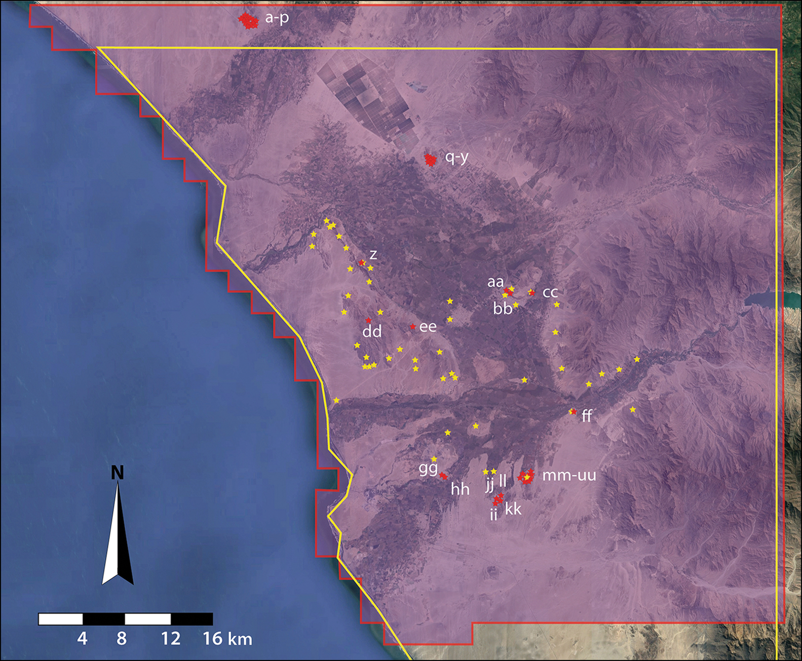
Figure 4. Comparison map of study areas and locations of defensive sites in the Jequetepeque Valley. Red boundaries and markers are from the GeoPACHA survey, yellow boundaries and markers are from Dillehay et al. (Reference Dillehay, Kolata and Swenson2009). For site details see online supplementary material (figure by the authors).
In total, 36 of the defensive sites registered during the GeoPACHA survey of the Jequetepeque Valley were novel while the remaining 11 sites aligned with those reported by previous pedestrian surveys, representing a 22 per cent agreement rate between digital and traditional surveys (Table 1). Kernel density-based heatmaps of site locations provide a visual comparison of GeoPACHA survey results (Figure 5a) and the locations of defensive sites reported by Dillehay and colleagues (Figure 5b) compared to GeoPACHA-identified defensive sites only (Figure 5c). In combination, digital and pedestrian survey campaigns in the Jequetepeque Valley have expanded the sample of fortified sites to 86, representing a 72 per cent overall increase (Table 1). In terms of relative time commitments between digital and pedestrian surveys in the Jequetepeque Valley area, the GeoPACHA survey represents 1.1–1.7 per cent of the total time commitment of the comparative pedestrian survey (229 hours versus 13 400–20 160 hours, Dillehay et al. Reference Dillehay, Kolata and Swenson2009).
Table 1. Corresponding and novel sites found in the Jequetepeque Valley digital and pedestrian surveys.
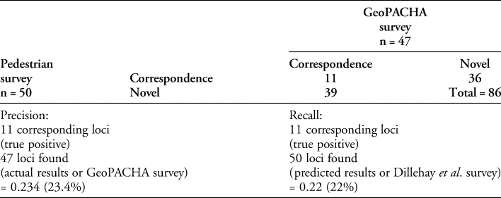
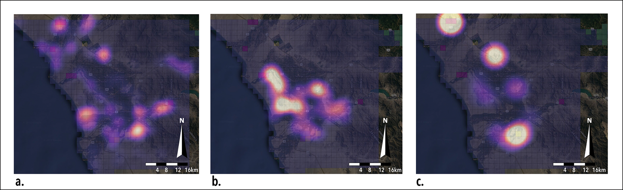
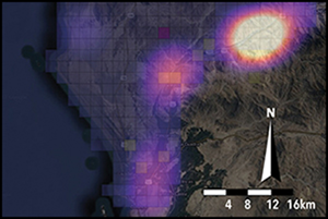
Figure 5. Heatmaps of site locations in the Jequetepeque Valley: a) all sites identified in the GeoPACHA survey (n = 47); b) fortified sites from Dillehay et al. (Reference Dillehay, Kolata and Swenson2009) (n = 50); and c) fortified sites only from the GeoPACHA survey (n = 36) (figure by the authors).
Lower Santa Valley survey comparisons
Wilson's 1979–80 survey noted 71 sites with clear evidence of fortification, many of which held enduring importance and were re-used as defensive outposts across several episodes of occupation (Figure 6, Table 2). Accordingly, at these 71 geographic locations the presence of multiple occupations increased Wilson's sample to 109 fortified sites dated to five regionally specific chronological periods of the lower Santa Valley: 20 sites from the ‘Cayhuamarca’/Early Horizon (c. 1000–350 BC); 12 sites from the ‘Vinzos’/Early Intermediate Period 1 (c. 350 BC–AD 1); 40 sites from the ‘Early Suchimancillo’/Early Intermediate Period 2 (c. AD 1–200); 32 sites from the ‘Late Suchimancillo’/Early Intermediate Period 3 (c. AD 200–400); and five sites dating to the ‘Guadalupito’/Moche/Early Intermediate Period 4 (c. AD 400–650) (Wilson Reference Wilson, Hass, Pozorski and Pozorski1987).
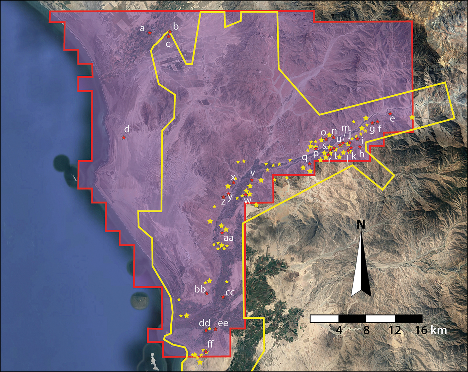
Figure 6. Comparison map of study areas and locations of defensive sites in the lower Santa Valley. Red boundaries and markers are from the GeoPACHA survey, yellow boundaries and markers are from Wilson (Reference Wilson1988). For site details see online supplementary material (figure by the authors).
Table 2. Corresponding and novel sites found in the lower Santa Valley digital and pedestrian surveys.
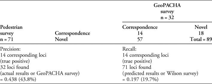
The GeoPACHA survey of the lower Santa Valley recorded 32 defensive sites. Given the difficulty in discerning multicomponent sites from satellite imagery alone, only the geographic locations of the 71 individual sites recorded by Wilson are used for comparison. Of the 32 sites found independently by the GeoPACHA survey of the lower Santa Valley, 18 appear to be novel, while the remaining 14 sites align with those found in Wilson's survey (Table 2). This overlap represents a 19.7 per cent agreement between surveys, closely replicating the results of the Jequetepeque comparison above. Four of the novel sites, however, lie just outside of the bounds of the Wilson survey area (Figure 6), bringing the number of novel sites to 14 if these are excluded. Again, heatmaps of site locations provide a comparison of overall GeoPACHA survey results (Figure 7a) as well as the relative locations of defensive sites reported by Wilson (Figure 7b) compared with the GeoPACHA-identified defensive sites (Figure 7c). In combination, the digital and pedestrian survey campaigns in the lower Santa Valley expanded the sample of fortified sites in this locality to 89, representing a 25.4 per cent increase overall (Table 2). In terms of relative time commitments between digital and pedestrian surveys in the lower Santa Valley area, the GeoPACHA survey represents 1.6–2.7 per cent of the total time of the original survey of the region (100 hours versus 3600–6000 hours, Wilson Reference Wilson1988).
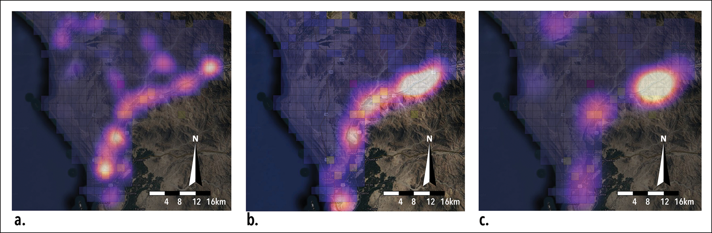
Figure 7. Heatmaps of site locations in the lower Santa Valley: a) all sites identified in the GeoPACHA survey (n = 32); b) fortified sites from Wilson (Reference Wilson1988) (n = 71); c) fortified sites only from the GeoPACHA survey (n = 18) (figure by the authors).
Discussion
Given the degree of overlap in the identification of defensive sites between the GeoPACHA survey and previous pedestrian surveys, the potential benefits of satellite imagery survey as an additional layer of site prospection are worth considering. The low level of correspondence is perhaps unsurprising, given the differing nature of satellite imagery and pedestrian survey. With more than 20 years of additional satellite data since the publication of the findings of the Proyecto Jequetepeque, it was assumed that more features would be visible, but the definition of sites as ‘defensive’ is still highly dependent on subjective categorisation. Small features such as slingstone piles, parapeted steps or isolated defensive walls are not visible to the digital surveyor and without access to the diagnostic artefactual evidence fundamental to pedestrian surveys, chronological assessment of GeoPACHA loci is difficult. Multicomponent sites that were used over a broad span of occupation phases present a further complication. Despite difficulties in assigning chronological phases to digitally surveyed sites, the capacity to reconsider such large areas with relatively minimal resource commitments provides a valuable asset in updating and ameliorating previous traditional surveys. The availability of high-resolution imagery from difficult to reach areas provides a significant increase in site identifications, supported by the degree of correspondence between surveys. The value of detailed remote survey through GeoPACHA lies in its use as a starting point for prospection efforts prior to the instigation of a time intensive pedestrian survey. In the coastal mountains of northern Peru, digital survey efforts represented a mere 1.1–2.7 per cent of the original pedestrian survey timeframe while increasing the overall number of identified sites by between 25.4 and 72 per cent. The structure of the GeoPACHA survey protocol simplified the collection, curation, peer-review and centralisation of data in an easily accessible online format.
Conclusion
Large-scale imagery survey via GeoPACHA has expanded our knowledge of the distribution of fortified sites across a targeted area of the northern coast of Peru, offering an opportunity to reconsider the sequence of social and environmental pressures that initiated and maintained these defensive actions. Nuanced study of each node in these fortification networks is needed for a more comprehensive analysis of changing relations in the Middle Horizon period and, although such analysis is beyond the scope of this article, the results presented here provide new data for such future studies. The preponderance of defensive infrastructure reiterates Dillehay's (Reference Dillehay and Pillsbury2001) suggestion of the likely social value of confederated construction events. Collective construction of these sites within the landscape united communities through powerful acts of defensive preparation that materialised and reified social cohesion in unsettled times.
As a starting point for future work, the overarching aim of the current study was to underline the need to reconsider and expand survey methods to include high-resolution satellite imagery data sources. In future, these data could be enriched with drone-based high-resolution orthomosaics of survey regions. Such low-altitude imagery would provide a level of detail that would drastically improve the recognition of many of the diagnostic features considered. By flagging potential targets for expanded exploration, the method presented in this article highlights the utility of a federated approach to digital survey within a broader community of scholars, with open access and integration of available data made possible through the centralised structure of the GeoPACHA. To this end, future directions of analysis should focus on a revisitation of all known defensive sites in relation to those that eluded discovery through GeoPACHA. Targeted ground-truthing of novel sites will also be required before this level of analysis can take place. This movement back and forth between the datasets will allow for a reconsideration of feature categories that will serve to elaborate future iterations of GeoPACHA, and potentially have utility in creating training sets for automated survey using deep learning algorithms (see Zimmer-Dauphinee et al. Reference Zimmer-Dauphinee, VanValkenburgh and Wernke2023). In the end, the fundamental importance of traditional pedestrian survey persists, but the added benefits of digital survey across vast areas, as offered by GeoPACHA, make clear that both methods can be employed in concert to reconsider previous surveys and afford continuous distributional views over areas too large to survey on foot.
Acknowledgements
We would like to thank the members of the GeoPACHA team for their input in survey design, as well as deepest appreciation to Edward R. Swenson, John P. Warner and Tom D. Dillehay for their insights on the field methods of their original pedestrian survey of the Jequetepeque Valley. The Vanderbilt University Spatial Analysis Research Laboratory provided computational support for this project.
Funding statement
Implementation-level funding for GeoPACHA was provided by an American Council of Learned Societies Digital Extension Grant (Steven A. Wernke, PI; Parker VanValkenburgh, co-PI). Graduate student funding and machine learning model development were supported by NSF Grant Award 2106717 (Wernke, PI) and NSF Grant Award 2106766 (VanValkenburgh, PI). The research and writing for this article were supported by a Postdoctoral Fellowship from the Vanderbilt University Data Science Institute and a Vanderbilt University Sesquicentennial Grant (Wernke, PI).
Data availability statement
The authors confirm that the data supporting the findings of this study are available from the corresponding author upon reasonable request.
Supplementary material
To view supplementary material for this article, please visit https://doi.org/10.15184/aqy.2023.176.


 Open access