当前位置:
X-MOL 学术
›
Remote Sens. Ecol. Conserv.
›
论文详情
Our official English website, www.x-mol.net, welcomes your feedback! (Note: you will need to create a separate account there.)
Mapping water content in drying Antarctic moss communities using UAS-borne SWIR imaging spectroscopy
Remote Sensing in Ecology and Conservation ( IF 5.5 ) Pub Date : 2023-10-13 , DOI: 10.1002/rse2.371 Darren Turner 1 , Emiliano Cimoli 1, 2 , Arko Lucieer 1 , Ryan S. Haynes 1 , Krystal Randall 3, 4 , Melinda J. Waterman 3, 4 , Vanessa Lucieer 2 , Sharon A. Robinson 3, 4
Remote Sensing in Ecology and Conservation ( IF 5.5 ) Pub Date : 2023-10-13 , DOI: 10.1002/rse2.371 Darren Turner 1 , Emiliano Cimoli 1, 2 , Arko Lucieer 1 , Ryan S. Haynes 1 , Krystal Randall 3, 4 , Melinda J. Waterman 3, 4 , Vanessa Lucieer 2 , Sharon A. Robinson 3, 4
Affiliation
|
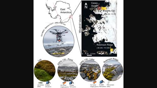
Antarctic moss beds are sensitive to climatic conditions, and both their survival and community composition are particularly influenced by the availability of liquid water over summer. As Antarctic regions increasingly face climate pressures (e.g., changing hydrology and heat waves), advancing capabilities to efficiently and non-destructively monitor water content in moss communities becomes a key research priority. Because of the complexity induced by multiple micro-climatic drivers and its fragility, tracking the evolution and responses of moss bed moisture requires monitoring methods that are non-intrusive, efficient, and spatially significant, such as the use of unoccupied aerial systems (UAS). In this study, we combine a multi-species drying laboratory experiment with short-wave infrared (SWIR) spectroscopy analyses to first develop a Random Forest regression Model (RFM) capable of predicting Antarctic moss turf water content (~5% error). The RFM was then applied to UAS-borne SWIR imaging data (900–1700 nm, <16 nm spectral resolution) of the moss beds at high spatial resolution (2 cm) across three sites in the vicinity of Casey Station, Antarctica. The sites differed in terrain, snow cover, and moisture availability to evaluate method capabilities under different conditions. Optimum RFM parameters and input variables (spectral indices and reflectance spectra) were determined. Maps of moss moisture were validated via acquiring moss spectra and water content (using sponges inserted into the moss turf) collected in situ, for which an exponential correlation (R2 = 0.72) was reported. RFM further allowed investigation of the influential spectral variables to model water content in moss and associated spectral water absorption features. We demonstrated that UAS-borne SWIR imaging is a promising new tool to map and quantify water content in Antarctic moss beds. Hyperspectral mapping facilitates the exploration of the spatial variability of moss health and enables the creation of a baseline against which changes in these moss communities can be measured.
中文翻译:

使用无人机搭载的短波红外成像光谱仪绘制干燥的南极苔藓群落的含水量
南极苔藓床对气候条件很敏感,它们的生存和群落组成尤其受到夏季液态水可用性的影响。随着南极地区日益面临气候压力(例如,水文变化和热浪),提高有效、非破坏性监测苔藓群落水分含量的能力成为一个关键的研究重点。由于多种微气候驱动因素引起的复杂性及其脆弱性,跟踪苔藓床湿度的演变和响应需要非侵入性、高效且具有空间意义的监测方法,例如使用无人占用的航空系统(UAS) 。在这项研究中,我们将多物种干燥实验室实验与短波红外 (SWIR) 光谱分析相结合,首先开发了一种能够预测南极苔藓草皮含水量(~5% 误差)的随机森林回归模型 (RFM)。然后将 RFM 应用于南极洲凯西站附近三个地点的高空间分辨率 (2 厘米) 苔藓床的 UAS 短波红外成像数据 (900–1700 nm,<16 nm 光谱分辨率)。这些地点的地形、积雪和水分可用性各不相同,以评估不同条件下方法的能力。确定了最佳 RFM 参数和输入变量(光谱指数和反射光谱)。通过获取原位收集的苔藓光谱和水分含量(使用插入苔藓草皮的海绵)来验证苔藓水分图, 报告了指数相关性( R 2 = 0.72)。RFM 进一步允许研究有影响的光谱变量,以模拟苔藓中的水分含量和相关的光谱吸水特征。我们证明,无人机搭载的短波红外成像是一种很有前途的新工具,可以绘制和量化南极苔藓床的含水量。高光谱测绘有助于探索苔藓健康的空间变异性,并能够创建衡量这些苔藓群落变化的基线。
更新日期:2023-10-14
中文翻译:
使用无人机搭载的短波红外成像光谱仪绘制干燥的南极苔藓群落的含水量
南极苔藓床对气候条件很敏感,它们的生存和群落组成尤其受到夏季液态水可用性的影响。随着南极地区日益面临气候压力(例如,水文变化和热浪),提高有效、非破坏性监测苔藓群落水分含量的能力成为一个关键的研究重点。由于多种微气候驱动因素引起的复杂性及其脆弱性,跟踪苔藓床湿度的演变和响应需要非侵入性、高效且具有空间意义的监测方法,例如使用无人占用的航空系统(UAS) 。在这项研究中,我们将多物种干燥实验室实验与短波红外 (SWIR) 光谱分析相结合,首先开发了一种能够预测南极苔藓草皮含水量(~5% 误差)的随机森林回归模型 (RFM)。然后将 RFM 应用于南极洲凯西站附近三个地点的高空间分辨率 (2 厘米) 苔藓床的 UAS 短波红外成像数据 (900–1700 nm,<16 nm 光谱分辨率)。这些地点的地形、积雪和水分可用性各不相同,以评估不同条件下方法的能力。确定了最佳 RFM 参数和输入变量(光谱指数和反射光谱)。通过获取原位收集的苔藓光谱和水分含量(使用插入苔藓草皮的海绵)来验证苔藓水分图, 报告了指数相关性( R 2 = 0.72)。RFM 进一步允许研究有影响的光谱变量,以模拟苔藓中的水分含量和相关的光谱吸水特征。我们证明,无人机搭载的短波红外成像是一种很有前途的新工具,可以绘制和量化南极苔藓床的含水量。高光谱测绘有助于探索苔藓健康的空间变异性,并能够创建衡量这些苔藓群落变化的基线。


 京公网安备 11010802027423号